Systems Tool Kit (STK)
Modeling, simulation, analysis, and operations software
Highlights
-
High-fidelity orbit propagators
-
WGS84 globe model
-
Dynamic field-of-view visibility analysis
-
Orbit element conversions
-
Coordinate system transformations
-
Attitude rotations and conversions
Description
Systems Tool Kit® (STK) is a 2D and 3D modeling environment used by engineers, mission analysts, operators, and decision-makers from more than 700 global organizations. These users model complex systems such as aircraft, satellites, ground vehicles, and their sensors to evaluate their performance in real or simulated time. Built on a time-dynamic, physics-based geometry engine, AGI software answers fundamental questions essential to solving dynamic analysis problems, including:
- Where are my assets and how are they oriented?
- What can my assets “see” and what can “see” them?
- What is the quality of the relationships?
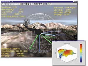
The STK/MATLAB Interface serves as a communication bridge between the analytical and visualization engines of STK and the flexible MATLAB® workspace. With the STK/MATLAB Interface, users can evaluate mission or relative geometric conditions such as range or inter-visibility between objects or signal-to-noise ratio. When a specific figure of mission effectiveness or geometric condition is met, MATLAB can automatically begin additional functions. MATLAB users can take advantage of STK’s 2D and 3D visualization to view any geo-referenced or geometric MATLAB data, such as position or attitude information or an antenna gain pattern. Visualizing this data provides an intuitive understanding of it and allows you to view the effects of the data within a mission.
Analytical Graphics, Inc.
220 Valley Creek Blvd
Exton, PA 19341
UNITED STATES
Tel: 610-981-8000
Fax: 610-981-8001
info@agi.com
https://www.agi.com/
Required Products
Platforms
- UNIX
- Windows
Support
- On-site assistance
- Telephone
- Training
Product Type
- Data Analysis Tools
Tasks
- Control Systems
- Data Analysis and Statistics
- GPS, Mapping and Navigation
- System Modeling and Simulation
- Operations analysis
Industries
- Aerospace and Defense
- Communication Infrastructure
- Earth, Ocean, and Atmospheric Sciences
- Utilities and Energy